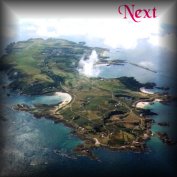
a. Burhou and Little Burhou
The earliest known map showing all of the Channel Islands, with some detail, was made by Thomas de Soulemont about 1540. It was incorporated by Leyland in his Survey or Itinerary of the British Isles, drawn up for Henry VIII between 1534 and 1545. The original hand drawn and annotated sketch is in Leyland's MS notes in the Bodleian Library in Oxford. The Itinerary was published in 1710 by Thomas Hearne and includes a smaller version of the map, about ¼ size, with the Latin text properly edited and printed. In both versions, 'Bureho' is noted as "an island with many rabbits". Another old map notes Burhou as "an island of much fern [bracken] and many conies [rabbits], a situation which still exists today.
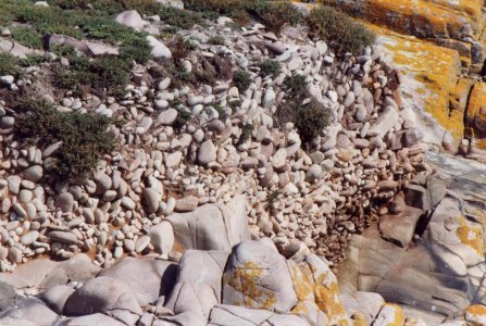
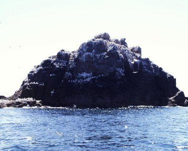
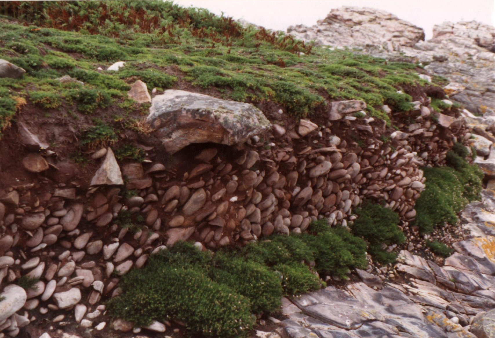 Geologically Burhou is part of the sandstone reef, extending about 20 miles, from Le Cap de la Hague in Normandy to Les Casquets. At the NE end a well developed 8m raised beach is to be found, relic of the water levels before the last ice age. (Fig. 112 on left). A similar beach, at the same height above sea level, is to be found on Little Burhou, (Fig. 113 on right below).
The earliest reference to birds on Burhou which I have found is given by an engraving published by Andrew and Sons about 1830, showing "The Petiel, or Sheerwater, from the Isle of Burhou, near Alderney". This
 picture has been interpreted as showing the Manx Sheerwater, (a bird still seen on the island in small numbers) but, to my mind does not have the white underbelly of the Sheerwater and looks rather more like the Storm Petrel. This, the smallest European sea-bird, about the size of a Sparrow, spends most of its life out in the Atlantic and only comes ashore in the breeding season to nest. At this time they are nocturnal. At sea they fly like a bat, just above the surface of the water, on which, as the picture Fig. 114 below shows, they often appear to walk. They frequently follow ships, giving them the name amongst sailors of 'Mother Carey's Chickens'. In the 1960s these nested in dry stone walls and amongst rocks on Burhou in their thousands. They are much less common today, but bird ringers on the island on 15-16th July 2000, ringed over 200, trapped in mist nets, ringed and released again, in the two nights.
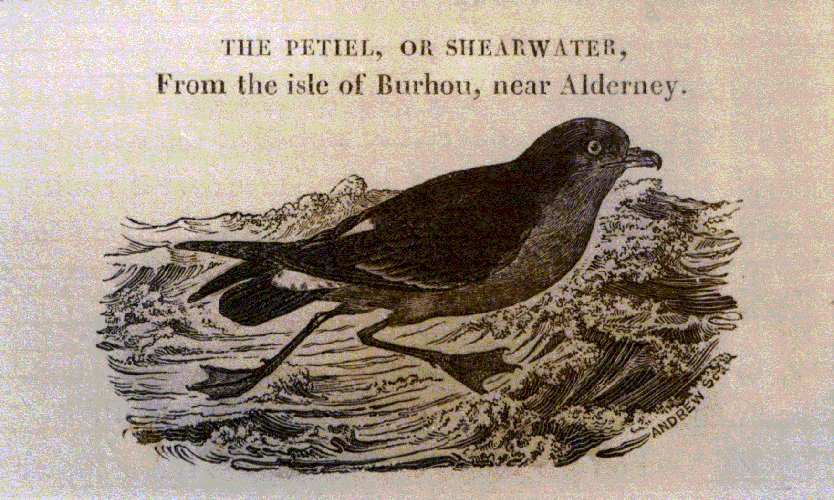
Four of these c. 200 birds had already been ringed in the Scilly Isles and one in France. They spend the winter in the South Atlantic and earlier ringings have been recovered off Southern Africa.
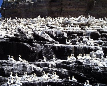
Burhou is an important breeding ground for seabirds. Again in the 1960s, Puffins in their thousands nested there, mainly in old rabbit burrows, population estimates in excess of 100,000 being given. These numbers gradually dwindled as supplies of their principal food, Sand Eels, diminished, probably through overfishing. Predation by the Great Blackback Gull, some pairs nesting on Little Burhou, with three or four nests on Burhou itself, may also have had some small effect. By about 1990 numbers were down to possibly less than 100 pairs. These have gradually increased to around 300 pairs. Herring Gulls nest in their hundreds amongst the Bracken here and many pairs of Lesser Blackback Gulls. Wheatears, Rock Pipits and other species have also been recorded breeding on the island.
Some years ago the States of Alderney declared Burhou to be a bird sanctuary and forbade landing on the island during the breeding season from 23rd March to 23rd July. This time span has been changed slightly on at least two occasions. First it was lengthened by 2 weeks to allow late hatched Puffins time to leave their nests and some years later reduced again for political reasons to extend the "tourist trade" to the sanctuary. This prohibition on landing has been well observed for many years by most people, but still does not have the actual force of a law and is abused by the few.
Burhou is about 1 mile from Alderney on the
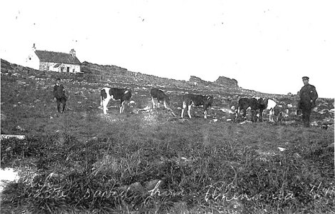
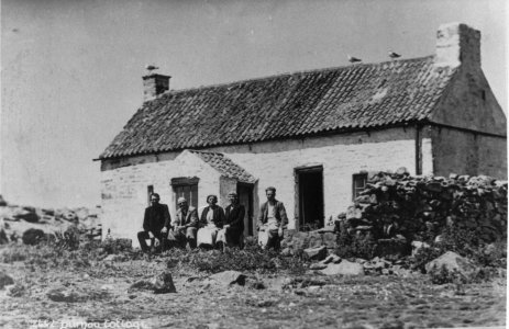 other side of the swift tidal channel of Le Swinge, the main route to Alderney Harbour from the south. It is about half a mile long and 3-400 yards wide at its widest. Little Burhou is separated from the main island by a narrow tidal channel and is only about 300 yards across. The islands have been the scene of many wrecks in the past and long ago, a stone cottage was built on the island for the use of fishermen and wrecked or stranded sailors, (Fig. 115 on right about 1930). On 7th April 1912, the SS Rhenania carrying cattle and a mixed cargo was wrecked on Burhou. The crew all managed to scramble ashore after releasing most of the cattle to swim for it. A few were lost, but the rest got ashore, (as Figure 116, below left shows). It took about three weeks, during which the crew salvaged most of the cargo and the cattle were left in the care of the mate, before the cattle were able to be removed to Alderney. In the 1920s a French family lived on the island for a few years and kept cows and sheep there This cottage was demolished by the Germans during WWII for target practice for t
 heir guns on Alderney. Some time after the war local people rebuilt the cottage as a holiday cottage. Somewhat primitive, it sleeps 6 people, all supplies needed during their stay, including drinking water, have to be taken with them. In the last few years visitors have been provided with a 2-way radio to link them to the Harbour Office in an emergency.
There is a small source of fresh water on the island, seeping from a spring below the peaty soil and collected in a trough, just above the beach on the north side, (Fig. 117 on left below). The overflow from this creates a brackish habitat just around the trough and is the site of our only colony of Sea C
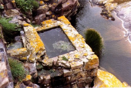 lubrush (Bolboschoenus maritimus) (Fig. 118 on right below), first noted here in 1901 and still thriving..
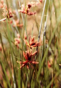
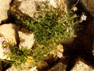
The vegetation of Burhou has, until recently contained very little grass. The principal herbage on which rabbits, cattle and sheep have fed over the years being Rock Sea-spurrey (Spergula rupicola) (Fig. 119 on left below). In midsummer, seen from Alderney's SW cliffs, the pink haze of this plant in flower is clear.
On Little Burhou by contrast, separated by less than 50m at high tide, this was only found in very small quantity, the dominant s
 pecies, (at least since records were first made there in 1901), has always been Sea Campion (Silene uniflora) (Fig. 120 on right below), a plant absent from the larger islet until after the 1987 hurricane. Then the wind came mainly from the SW and presumably carried seed or vegetative material of the Campion with it. By 1993 there were a number of patches up to 1m across, mostly adjacent within 100m of the nearest shore. These gradually scattered themselves further across Burhou and by 1999 some of these
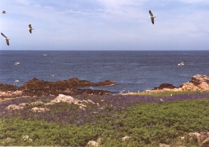
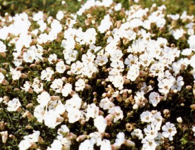 patches had spread to 30-50m across, suppressing the Sea-spurrey. In spring much of Burhou outside the areas of Bracken turns blue with the native Bluebell (Hyacinthoides non-scripta) (Fig. 121 below). The colour haze produced by this too, in season, can clearly be seen from Alderney's cliffs.
Use of the hut by residents and visitors since the 1920s has gradually introduced new species, particularly around the hut itself, and a list of the species found on the islets and stacks dealt with in this section will be found at its end.
.
.
b. Les Casquets
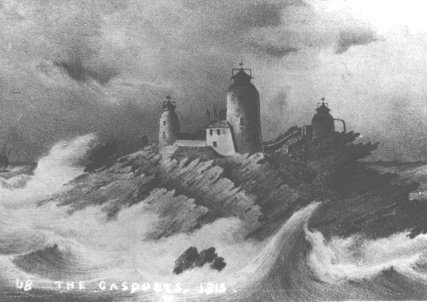
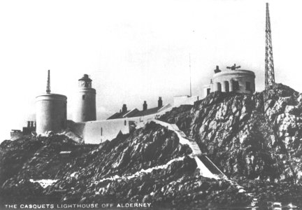
The Casquet rocks forming a group of emergent stacks about ½ mile across, mark the western end of the sandstone reef and have been the site of many shipwrecks, both before and since the first three Lighthouses were erected there in a triangle in 1724. From that time until 1997 the lighthouses were continuously occupied by families, originally from Alderney who spent many years there and cultivated the terraces they constructed in a sheltered spot for vegetables for their own consumption. Regular supplies were brought from Alderney by small tenders. In early days the three towers were of equal height and each housed a coal fire which had to be tended continuously. These were gradually replaced over the years by oil lanterns and the towers were altered in height with a clockwork mechanism to turn the ring of lanterns installed, which had to be wound by hand every 1½ hours. Trinity House keepers resident in Alderney later took turns of about 2-3 weeks duty to man the lights, a semaphore signalling station was replaced by radio and later radio telephone and finally a single more powerful petrol vapour light installed, later in the 1950s replaced by electricity. The last phase in the operation was making the installation completely automatic, controlled from Lowestoft and withdrawing the keepers in 1997.
.
.
.
.
..
.
......Figure 122 Casquets in 1815......................................................................................................................................Casquets in 1938. Note terraced garden
area,.in dip below tallest tower.....
............. and radio mast on right..........
.
.
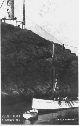
Fig. 124. Relief boat MV Burhou arriving c. 1936...>>>
.
.
.
.
.
.
.
.
.
.
.
.
.
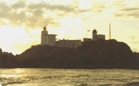
Fig. 125. Sunset over Casquets , July 1989
Note helicopter landing pad on central tower
.
c. Cocque Lihou
A small islet about 500m off Alderney's south coast, this is covered with a limited vegetation and is the nesting place of many Gulls, and small numbers of Little Auks, Razorbills and Guillemots.
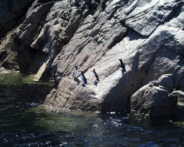
(Fig 126, Guillemots & Razorbills on Cocque Lihou)
.
d. Les Étacs, (The Garden Rocks)
The nesting site of thousands of pairs of Gannets, as mentioned in the previous section, their activity and the acid nature of their droppings makes vegetation extremely rare here. The Gannets bring in sections of Hottentot Fig (Carpobrotus edulis) as nesting material, but this and Sea Beet are the only plants recorded. The rocks are frequently swept clean by the winter gales and high sea and the white manure washed off by wave action.
e. Ortac
The other Gannet colony off Alderney, the position of this has already been shown in the last section. No vegetation seems to have survived here for much the same reason and the white cone-shaped rock left as the Gannets depart in late September/October is usually washed clean by the time they return in January
.
.
.
.
.
.
.
Fig. 127. Gannets on Ortac June 1999............................................................................................................... Fig. 128. Gannets on lower ledges of Ortac
.
.
.
.
Checklists for the plants on the Off-Islets
.
1. Burhou
Updated by the author 1987, 1991, 1993 and 1999. All species present 1987-93 unless noted. On 15/7/1999 visit, many were past flowering and not recorded.
TSG signifies recorded in the Transactions of La Société Guernesiaise for that year. Other sets of initials are those of the recorders on the date noted.
Frequencies noted are; abundant; common; frequent; occasional; rare. Some of these are qualified by locally or very.
| Scientific name | Frequency | Notes, recorders, dates, etc. |
| Pteridium aquilinum | a | Noted on Leyland's map of 1540. Still 'a' 1999, spread has been controlled somewhat by 1991/93 spraying |
| Asplenium marinum | r | TSG 1964 |
| Dryopteris filix-mas | EDM 1899 only | |
| Ranunculus repens | r | HP list 1974, '1972' |
| Ranunculus bulbosus | r | First record; One plant TSG 1964 |
| Ranunculus ficaria | o | TSG 1964 |
| Urtica dioica | o | EDM 1902. Spreading somewhat 1999 |
| Urtica urens | o | TSG 1964. Still 'o' 1999 |
| Atriplex prostrata | f | EDM 1901. Still 'f' 1999 |
| Atriplex glabriuscula | o | BB 1987. Still 'o' 1999 |
| Beta vulgaris ssp. maritima | r | DdeV 1927. A few plants seen 1999 |
| Honkenya peploides | o | TSG 1964 |
| Stellaria media | f | TSG 1964 |
| Cerastium fontanum | r | EDM 1901, HP 1971 |
| Sagina maritima | o | TSG 1964 |
| Sagina procumbens | f | TSG 1964, AS 1966, BB 1987 |
| Spergularia rupicola | a | DdeV1927. The dominant species to 1987. Areas being reduced by spread of S. unifora 1999 |
| Silene uniflora | vlf | EDM 1901, TSG1964, BB 1993, greatly increased since the 1987 hurricane. Now f. Very large patches 1999, one c. 100 x 80m. |
| Rumex acetosella | c | EDM 1902 ('o' in TSG 1964). 'f' 1999 |
| Rumex acetosa | o | BB 1993. 'lf' 1999 |
| Rumex crispus | lf | BB ('1899 only' in TSG 1964). Still 'lf' 1999 |
| Rumex obtusifolius | o | BB 1991. Increasing to 'f' 1999 |
| Armeria maritima | r | BB 1987 |
| Matthiola incana | l | BB 1987 |
| Cochlearia danica | c | TSG 1964. Appears 'r' 1999, but probably over for year |
| Anagalis arvensis | f | TSG 1964. Seems 'a' 1999 |
| Glaux maritima | r | ('r' in TSG 1964). Same 1999, 1 site |
| Umbilicus rupestris | f | TSG 1964. Spreading slightly 1999 |
| Sedum anglicum | o | ('r' in TSG 1964) |
| Rubus caesius | r | BB 1987 |
| Erodium maritimum | lc | ('f' in TSG 1964) |
| Crithmum maritimum | lf | ('o' in TSG 1964) |
| Solanum nigrum | o | EDM 1902 |
| Solanum tuberosum | r | TSG 1964 |
| Anchusa arvensis | o | TSG 1964. 1999, now frequent in landing area and in front of hut |
| Myosotis arvensis | o | TSG 1964 |
| Plantago coronopus | vlf | ('r' in TSG 1964) |
| Sambucus nigra | vr | BB 1 bush 1991, 2 in 1993, 1999 |
| Cirsium vulgare | r | AS 1966. Increasing to 'o' 1999 |
| Hypochoeris radicata | o | BB 1993 |
| Sonchus oleraceus | o | BB 1991, 1999 |
| Sonchus asper | o | TSG 1964, AS 1966. 'r' 1999 |
| Crepis capillaris | r | TSG 1964. not seen by BB |
| Crepis vesicaria | r | 3 plants BB 1993 |
| Taraxacum officinale | r | TSG 1964 |
| Tanacetum vulgare | HP list 1974 only, '1971' | |
| Hyacinthoides non-scripta | la | TSG 1964, 1999 |
| Juncus bufonius | f | TSG 1964 |
| Bolboschoenus maritimus | vr | ('r' in TSG 1964). Patch 3x1m by water trough on W side |
| Festuca rubra | r | TSG 1964. Large area of grass NW side, none flowering ?spp. 1999 |
| Festuca ovina | f | TSG 1964 |
| Poa infirma | c | ('r' in TSG 1964) |
| Poa annua | l | EDM 1902 5 plants, BB 1989 |
| Poa annua var. reptans | r | MH2 1977 |
| Poa trivialis | r | TSG 1964 |
| Dactylis glomerata | r | TSG 1964 |
| Holcus lanatus | o | HP list 1974, '1971' |
| Holcus mollis | ? | AS 1966 |
| Aira praecox | r | MH2 1977 |
| Agrostis capillaris | r | MH2 1977 |
| Agrostis stolonifera | r | TSG 1964 |
| Agrostis canina | r | HP list 1974, '1971' |
| Hordeum distichon | 1956 only |
2. Little Burhou
Frequency updated by the author 1991. All species seen. Not visited 1999, tides wrong for access.
| Atriplex prostrata | r | EDM 1901 |
| Sagina maritima | o | TSG 1964 |
| Spergularia rupicola | o | DdeV 1927 |
| Silene uniflora | a | EDM 1901. The dominant species |
| Rumex crispus | r | TSG 1964 |
| Cochlearia danica | o | TSG 1964 |
| Erodium maritimum | o | TSG 1964 |
| Sedum anglicum | r | TSG 1964 |
| Poa annua | o | TSG 1964 |
3. Casquets
Updated by the author 1989. (Earlier records not seen in my brief visit in 1989 starred *)
Lampranthus roseus BB Two small patches ? planted
Carpobrotus edulis BB Several large patches
Atriplex prostrata TWA 1958
Atriplex portulacoides* DdeV 1927
Beta vulgaris ssp maritima* DdeV 1927, TWA 1958 'plentiful'
Sagina maritima BB 1989
Spergularia rupicola* DdeV 1927
Spergularia rubra BB 1989
Silene uniflora BB 1989
Rumex crispus* DdeV 1927 (?as R. conglomeratus)
Rumex conglomeratus* DdeV 1927 (? error for R. crispus)
Armeria maritima TWA 1958, 'abundant'
Lavatera arborea A Mourant 1927, TWA 1958, 'plenty'
Cochlearia danica BB 1989
Umbilicus rupestris TWA 1958, '1 plant'
Melilotus indicus BB 1989
Eryngium maritimum* DdeV 1927
Crithmum maritimum TWA 6/1958, 'rare'
Daucus carota ssp gummifer* DdeV 1927
Plantago coronopus* DdeV 1927
Plantago major* DdeV 1927
Plantago lanceolata TWA 1958
Hebe x franciscana TWA 1958. (Probably planted)
Sonchus oleraceus* DdeV 1927
Crepis vesicaria BB 1989
Carex arenaria BB 1989
Catapodium marinum TWA 1958
4. Cocque Lihou
Beta vulgaris ssp. maritima DdeV 1927
Cerastium glomeratum HP list 1974, '1973'
Spergularia rupicola DdeV 1927
Silene uniflora HP list 1974
Armeria maritima HP list 1974
Lavatera arborea HP list 1974
Cochlearia danica HP list 1974
Umbilicus rupestris HP list 1974
Plantago coronopus HP list 1974
Dactylis glomerata HP list 1974
Catapodium marinum HP list 1974
Bromus mollis HP list 1974
5. Garden Rocks
Beta vulgaris ssp. maritima DdeV 1927
Carpobrotus edulis BB 1990
.
.
.6. Ortac
No vegetation has been recorded here. The stack gets washed clean of both guano and any possible vegetation during the autumn and winter storms.
.
.